
We’ve had a coolish week with some patchy frost early in the week and scattered rainfall mid to late week, while a severe weather threat which appeared to loom for the west Friday wound up being much further west. Saturday’s severe weather threat in the east just clipped far eastern sections of the eastern forecast district.
As we begin the new week, we’re fighting a lot of clouds left behind this weekend’s weather system, although drier northeast flow aloft is trying to give some pushback to the overcast skies. At the same time, some high clouds are headed east in westerly flow aloft so while eastern areas may go clear for a while, we’re not likely to see 100% clear skies today. The west may also see some breaks work in from the east this afternoon with some filtered sunshine through the scattered high clouds as well. Really, that will be the theme this week, periods of mid level or high clouds as a band of very active weather sets up to our south and west –right over the heart of the southern Plains drought zone. Certainly good news for them but not for the western district, which still needs rain and will finish April with sub-average rains. This may give an opportunity for dryness to give some recent improvement a slight push back. The upshot is, as of this writing there is no threat for severe weather through next Friday (at least).
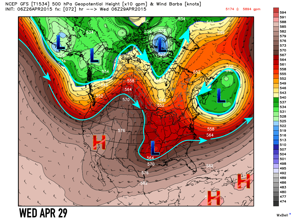
Let’s take a look at the upper air flow this week. Note how the main polar jet continues to retreat northward (heavy light blue arrows) Gone are the deep polar lows and vortexes of mid winter. The closed low which impacted our weather the week before last continues to spin off the northeast coast and will only slowly spin out into the Atlantic this week as another weaker version drops into the Northeast and takes up residence off SE Canada by next weekend. We’ll be watching a weaker closed low over the Southern Rockies Monday, which will track just south of due east into the Southern Plains Tuesday, the Mid South midweek and then fade away over the southeast by week’s end. This low will be the weather and rain maker for the drought-stricken southern Rockies and southern Plains, including northeast Texas. That’s where most of this week’s severe weather chances will reside. We’ll have to watch this low as a northward shift in the track could impact our weather by adding more clouds or some light rain opportunities. We’ll be dealing with periods of clouds all week at times due to the blowoff of rain and storm complexes to our distant west and south. We’re not going to have to deal with any totally overcast days, but as mentioned above 100% clear skies may not be achieved either. Partly sunny to mostly sunny might be a good way to describe it. If the low shifts north, we, might then see a few cloudier days. Aside from this upper low, the jet is pulling north and it means some milder to warmer weather will try to build in. The ridge of high pressure off the west coast Monday will push inland early next week and into the Southern Plains next weekend. This looks to bring a return to milder temperatures with 70s likely and perhaps some 80s next weekend.


Rainfall, as mentioned, is not expected this week. Most of the region expects little to no measurable rain this week. Lighter totals exist just west and south of the western district, which is why a subtle shift north in the upper low could bring some of these light totals into that area.

Here’s the latest on the drought as of last week’s update. Dryness has been held at bay in recent weeks for the west. Rainfall this week was around 1/2″ in Kansas City (at KCI – the official reporting station), and typical 7-day rains should be around 1.19 – now through the end of June, so we came up short “officially” at the airport again. With no rain this coming week, dryness may re-expand to reclaim recently lost ground locally, but may really be dealt a blow in the worse off areas further west across Kansas and south into Oklahoma. That’s good news for our summer rain setup- even if it’s bad news locally in the short term.

Week in Review:
It was a cool week relative to averages. The core of the cool weather extended from central Canada south through the Great Lakes and into the Northeast. Most of the immediate California coast, southern Rockies, Southwest, Plains Midwest, Ohio Valley, Tennessee valley and Mid Atlantic were cool. The Gulf Coast, Florida, the Inter-mountain West and Pacific Northwest were warmer than average.

The chill brought threats of frost and frost Advisories to the eastern district where lows in the 30s were expected.


Here’s a look at this past week’s rain. Less than impressive in the west, but eastern areas especially the STL metro and S IL had decent totals. SE Missouri had totals less than 1″. (Click to make each map more readable.)


Severe weather was limited, with a threat on Saturday for the eastern district. The entire area was placed under a Tornado Watch at mid day, but the only severe cluster wound up being a series of storms which formed and tracked through south central Illinois. these storms clipped Jackson and Perry Counties in Illinois.

Severe thunderstorm warnings were issued due to wind and hail threats for Jackson County, but the strongest cluster went on through Williamson and Saline County of Southern Illinois and eventually crossed into western Kentucky where the nearest tornado warning was issued. This radar image from 4:16 PM shows the severe storm over Saline County IL and then storm NW of Murphysboro IL in Jackson County which would go on to prompt a warning for wind and hail as it tracked through De Soto, and on down toward IL Route 13 and on into Williamson County. The pink and purple tones show areas of likely large hail.

The watch was cancelled for the entire region several hours ahead of schedule. Despite clearing, westerly low level winds and drier air quickly shut down severe potential. That was good news as upper level parameters were looking good for severe weather earlier in the day.
Global Tropics:
There were no tropical cyclones in either hemisphere and really no candidates for development at least the next several days. We’re just over two weeks from the beginning of the Eastern Pacific hurricane season and the NW Pacific season could begin ramping up at any time as well.
It should be a quiet week, so we’ll update the drought map on Thursday on FB and our next blog update will be next weekend when we look at May and see what patterns look to prevail as we head into the last week of meteorological spring. Should any severe weather risks appear, we’ll also place a FB post with the risk area, but right now, there don’t appear to be any severe threats for us.
